Normandy case study
- General characteristics
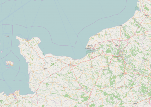
This case study is located in the north-western part of France. The area includes the bay of Mont Saint-Michel, which is listed by UNESCO as world heritage, and Cancale bay, which does not belong to the Normandy Region per se, but is in the same ecoregion. On a whole, the length of the coastline is about 450 km, and the total area is around 20 000 km2 (including terrestrial and marine zones). The area does not include Channel Islands which are independent and have their own administration.
- Types of aquaculture
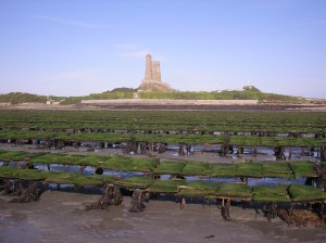
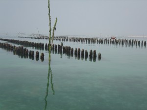
Shellfish aquaculture dominates in several places along Normandy coasts, mostly in sheltered areas (bays, estuaries). Two species are cultivated: the Pacific oyster, Crassostrea gigas, and the blue mussel Mytilus edulis. Oysters are placed in plastic bags fixed on metallic tables moored in the sediment. The tables are about 70 cm above the sediment. Mussels are generally cultivated on wooden poles. For the whole area (Normandy including bays of Mont Saint Michel & Cancale), oyster annual production is around 34 000 t and total mussel annual production averages 29 000 t.
Marine fish aquaculture is represented through 2 salmon farms. One farm is located in the harbor of Cherbourg in the northern part of Cotentin, where salmons are bred in cages. The second one is a land-based farm located in the eastern part of Cotentin, where salmons are produced in a sea water recirculation system. The total annual salmon production is 2000 t.
- Relevance of the case study in AquaSpace
Existing issues
Normandy represents a series of economic, cultural and environmental issues due to a large panel of activities (e.g. shellfish farming, tourism, commercial fishing, agriculture, nuclear power plant, fuel processing industries, sand gravel extraction and, in the future, offshore renewable energy) and a complex governance system inherited from several administration. Issues have been identified in a report by the French Agency for Marine Protected Area [1] as following:
- Protect key marine habitats
- Understand and preserve coastal ecosystems in relation to ecosystem functions and land/sea interactions
- Maintain seabirds and marine mammals diversity
- Improve water quality and maintain primary productivity of the coastal zones
- Struggle against invasive species (e.g. limpet Crepidula fornicata) which affects coastal biodiversity and productivity
- Improve the coherence and transparency of decision-making process regarding coastal zone management, including a better integration with Channel islands
- Develop new uses in the coastal zone
- Promote sustainable activity, including aquaculture and fishery
Policy
Traditionally, rules fixing aquaculture activities are driven by departmental structure schemes (SDS). More recently, a regional scheme for marine aquaculture development (SRDAM) was set up. It aims at identifying existing aquaculture areas and new potential areas for aquaculture development. Both are integrated into the framework set up by the French government to address Marine Spatial Planning issues. New measures are also under development.
A MSP demonstrator tool already developed
A GIS tool based on AkvaVis (www.akvavis.no), which has been originally developed by IMR and CMR Computing (Norway) has already been adapted to Normandy. The fundamental concept of AkvaVis consists in integrating information, model simulations, and regulatory framework with expertise by applying a web based dialogue and by allowing instant response from simulations to the user. Initially applied to the Normandy region to identify potential areas for aquaculture and optimize aquaculture (e.g. select areas with higher environmental quality, lower risk of infection by pathogens and mortality, better growth), it will be expanded to all spatial information necessary to minimize conflicts between aquaculture and other uses.
- Aquaculture development issues
The French AquaSpace team held a stakeholder workshop on March 2nd 2016 in Caen. The WS was co-organized with the national authorities (French Ministry of Environment, Energy and Sea), more specifically the Inter-Regional Direction of the Sea (DIRM) and the Departmental Directions of Territory and Sea (DDTM). The WS was physically held at DDTM of Calvados Department and was specifically dedicated to the AquaSpace project.
A total of 28 persons (without Ifremer) from 18 organisms participated to the WS which was managed by the Ifremer AquaSpace team.
The WS started with several presentations:
- Introduction to the European Directive for Maritime Spatial Planning (MSP), application in France and on the area Eastern Channel – North Sea, step report – DIRM.
- Presentation of the AquaSpace project (objectives, methods) and SISAQUA application – IFREMER.
- What is the administrative procedure applied to projects development in aquaculture? – DDTM.
Then, exchanges with stakeholders were organized with the objectives of i) identifying & ranking the data needed to implement aquaculture spatial planning in the area, ii) verifying the existence & availability of these data and precise their format. Two working groups were set up, each of them managed by 2 Ifremer participants. An immediate restitution of the working groups and an open discussion about the issues of aquaculture development in the area took place in the last part of the WS.
Main issues regarding to aquaculture development in Normandy have been identified on the basis of exchanges during the WS and consultation of the French Strategic National Plan for Aquaculture Development (PSNPDA, [2]):
Policy and management issues
- Complexity of procedures regarding projects installation
- Multiplicity of services/structures involved in the procedures and zoning systems
- Transparency in the decision making process
- Too long case investigation duration
- Lack of a unique regulatory tool for a quick diagnostic, integrating a maximum of aquaculture types
- Difficulty/Constraints related to the civil society consultation process
- Lack of a political willingness to develop aquaculture at global and local scales
Economic and market issues
- Lack of well identified consumers’ expectations (need of market studies)
- Need to better know the international market (competitiveness issues)
- Mismatch between market reality and time needed to start a new production
- Need to develop an industry based on high quality products and eco-aware
- Need stability and reliability of the production system
- Difficulty to predict costs related to externalities (energy costs, feeding costs)
- Lack of already existing infrastructures which would facilitate settlement of new farmers/activities
Aquaculture-Environmental issues
- Existing risks non taken into account: submersion, coastline erosion
- Evaluation of emerging risks, diseases
Aquaculture-Other sectors issues
- Need to balance aquaculture activities with respect to other ecosystem services provided by coastal ecosystems (patrimonial issues)
- Lack of a society willingness to develop aquaculture at global and local scales ; Acceptability
Global issues on data/tools
- Lack of knowledge on information/data relevant to aquaculture and about their availability
- Up-date of data, tools / make them durable
- Friendly tool(s) (design for different users)
- Transfer of tools
- References
[1] AAMP. 2009. Analyse des enjeux et propositions pour une stratégie d’aires marines protégées Bretagne Nord / Ouest Cotentin. Agence des Aires Marines Protégées. 38 pp + annexes.
[2] MEDDE. 2014. Plan Stratégique National : Développement des aquacultures durables 2020. Ministère de l’Ecologie, du Développement Durable et de l’Energie avec la contribution de l’Association des Régions de France. 103 pp + annexes.


