German case study
Case study North Sea, Germany
Contact person: Antje Gimpel, Thünen-Institute of Sea Fisheries, Germany
Characteristics:
The German case study site refers to the German EEZ of the North Sea and adjacent coastal waters (Figure 1). The German EEZ is featuring an area of ca. 28600km², the German coastal zone is featuring an area of ca. 11400km².
Aquaculture:
Recently, existing license areas of 3.300ha are designated for bottom cultures of blue mussel with a production of round about 5000t/y. Those are located within the Wadden Sea National Park (Figure 2), which falls under the jurisdiction of the federal state of Schleswig-Holstein and exhibits numerous restrictions regarding human activities.
Relevance of the Case Study within AquaSpace
Within the German EEZ, Marine Spatial Planning (MSP) is legally binding since 2008 and was mainly driven by the development of offshore renewables. The plan comprises designated preference areas for a number of sectors (shipping, cables and pipelines, offshore renewable development, and extraction of non-living resources) except fishing, including whereas special areas of conservation (BMVBS, 2009). In contrast, spatial management within the coastal zones, ranging from mean tide high-water seawards until the 12 nm limit, falls under the restriction of the federal states of Lower Saxony, Hamburg and Schleswig-Holstein.
According to the national aquaculture strategy (http://www.portal-fischerei.de/fileadmin/redaktion/dokumente/fischerei/Bund/Nationaler_Strategieplan_Aquakultur_Deutschland.pdf), the main factors hampering aquaculture development in Germany are the legal requirements regarding environmental law, federal waterways law, fisheries law, building law or veterinary legislations, which lead to expensive and time consuming approval procedures. A pooling of responsibilities did not happen yet. Furthermore, aquaculture is afflicted with a bad image and implementation issues such as e.g. the influence of predators, protected species etc.
Facing the need for blue growth and the EU aquaculture strategy (http://ec.europa.eu/fisheries/cfp/aquaculture/strategy/index_en.htm), investigations are needed concerning research to guarantee for ecosystem compatible aquaculture operations.
For the German case study, the focus is on the assessment of potential conflicts of the national aquaculture strategy, which foresees an increase of the current blue mussel production from 5000t to 40000t within the existing license areas. This includes the mapping of potential interactions with other human uses. The outcome is a comprehensive evaluation of the production increase scenario including economic aspects which can be provided to the responsible authorities.
Further, potential synergies between offshore windfarms and Integrated Multi Trophic Aquaculture (IMTA) systems are analysed. To date 22% of the current offshore wind development applications, in total covering approx. 30% of the EEZ, have been granted. The enormous spatial expansion of this sector exerts pressure on other human uses such as fisheries. To mitigate this increasing conflict potential, the German planning authority is currently interested in the development of suggestions for potential synergies between different sectors such as offshore wind development and aquaculture. This call for the co-location of activities requires comprehensive spatial modelling approaches to identify potential areas of co-location of those two activities (Gimpel et al., 2015). The expected outcome is a transparent and spatial explicit risk assessment of co-location scenarios which can be provided to the German planning authority to inform the upcoming revision process of the MSP.
The German EEZ case study scenarios would exhibit on both, i) allocated zones at a small scale (German coastal zone) where production will be intensified and ii) areas of potential compatibility between uses at a large scale (German EEZ). Furthermore, the German case study features a broad field of laws and restrictions regarding human activities, which falls under the jurisdiction of the federal states, giving a solid basis for a legal analysis.
Suitability maps for a range of different aquaculture candidates will be combined with economic, technical and legal constraints and an environmental impact assessment to assess the overall risk of both scenarios. In turn, this requires detailed spatial information on environmental parameters, the transfer of technical sectoral requirements and economic considerations into spatial data. The environmental impact assessment comprises the definition of vulnerable ecosystem components and their potential exposure (Gimpel et al., 2013). Moreover, the co-use scenarios will be built on previous results and make use of existing environmental data sets, suitability models based on multi-criteria-analysis for a range of offshore aquaculture candidates and constraint maps (Gimpel et al., 2015). Designated is a transparent and spatial explicit risk assessment usable out of all relevant perspectives: the administrative, the social and the business operator one.
Past experience showed that decision support tools should be build bottom-up in the sense that stakeholder should be engaged to identify required functionality and outputs (Stelzenmüller et al., 2012). For this case study close collaboration exits already with the main stakeholders.
Stakeholder meeting arranged (date)
A stakeholder meeting is envisaged for April the 14th. Invited are 30 stakeholders from the field of nature conservation, politics, economy, science and administration.
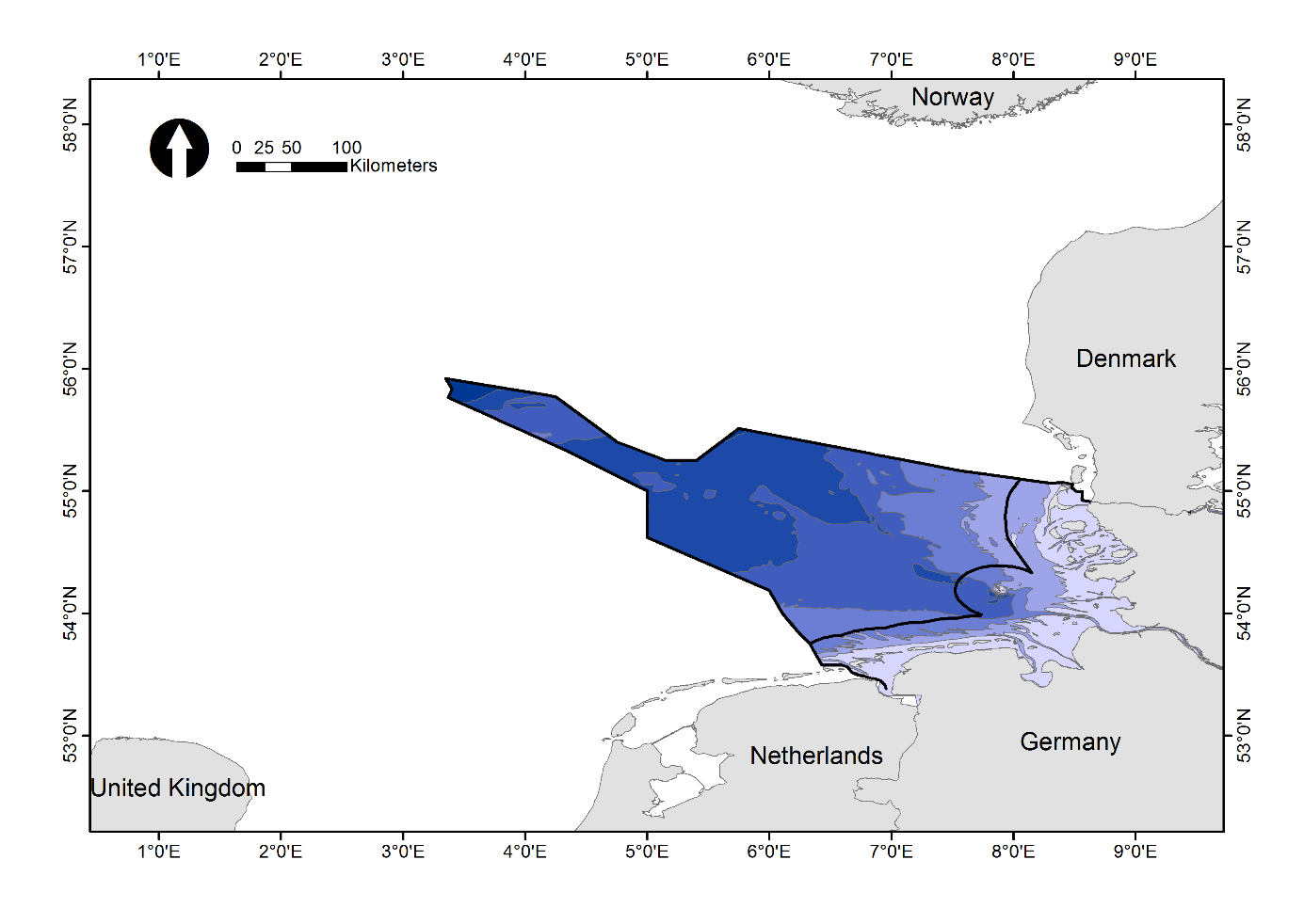
Figure 1: German EEZ of the North Sea with adjacent coastal waters, embedded between Denmark and the Netherlands with a maximum depth of 60 meters.
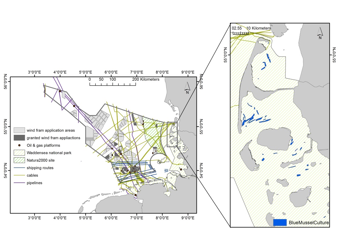
Figure 2: German EEZ of the North Sea with adjacent coastal waters showing the main offshore activities managed by maritime spatial plan. Blue mussel licence areas are located 20 km of the coast close to the island of Sylt within the Waddensea national park.
References
BMVBS, 2009. Spatial Plan for the German Exclusive Economic Zone in the North Sea. http://www.bsh.de/en/Marine_uses/Spatial_Planning_in_the_German_EEZ/index.jsp.
Gimpel, A., Stelzenmüller, V., Cormier, R., Floeter, J., Temming, A., 2013. A spatially explicit risk approach to support marine spatial planning in the German EEZ. Marine Environmental Research 86, 56-69.
Gimpel, A., Stelzenmüller, V., Grote, B., Buck, B.H., Floeter, J., Núñez-Riboni, I., Pogoda, B., Temming, A., 2015. A GIS modelling framework to evaluate marine spatial planning scenarios: Co-location of offshore wind farms and aquaculture in the German EEZ. Marine Policy 55, 102-115.
Stelzenmüller, V., Lee, J., South, A., Foden, J., Rogers, S.I., 2012. Practical tools to support marine spatial planning: A review and some prototype tools. Marine Policy.
